

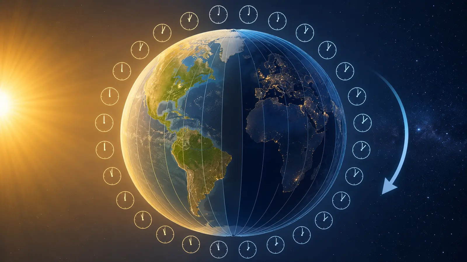
Why do time zones exist if every clock is measuring the same passing seconds? The answer begins with Earth itself. Our planet rotates, so sunrise, noon and sunset reach different longitudes at different moments. A single worldwide clock would be technically possible, but it would make noon arrive in the dark for much of the world. Time zones let communities keep clock time roughly connected to the local cycle of daylight while still sharing a common system.
That system looks tidy on a globe but becomes wonderfully human on a map. The ideal geometry suggests 24 strips, each about 15 degrees of longitude wide. Real boundaries bend around countries, islands, trade relationships and political choices. Some places use half-hour or quarter-hour offsets, and some move their clocks seasonally.
Quick answer: Time zones exist because Earth turns through 360 degrees in about 24 hours, causing different places to face the Sun at different times. Dividing the world into regions with shared clock settings makes travel, work and communication practical while keeping daytime hours near the familiar part of the clock. Governments choose the actual boundaries and offsets. That is the short answer to why do time zones exist.
Why do time zones exist in simple terms?
Imagine two towns separated from east to west. The eastern town turns toward the Sun first, so its solar noon—the moment the Sun reaches its highest daily point—happens earlier. If both towns set 12:00 noon only by observing the Sun, their clocks will disagree. A small difference is manageable between neighbours, but across a continent it becomes hours.
Before fast transport and communication, many communities used their own local solar time. A town clock could be set from the Sun, and a traveller adjusted after arriving. Once trains, telegraphs and national businesses connected distant places, thousands of slightly different local times became a scheduling problem. Time zones replaced them with larger regions in which everyone agrees to use the same civil time.
| Term | Plain meaning | What determines it |
|---|---|---|
| Solar time | Time inferred from the Sun’s apparent position | Longitude, season and Earth’s orbital motion |
| Civil time | The legal clock time used in daily life | Government rules for a place |
| Time zone | A region sharing a civil-time rule | Boundaries, a UTC offset and possible seasonal changes |
| UTC offset | How far local time is ahead of or behind UTC | The zone rule in effect at that date |
| Date Line | The approximate boundary between consecutive calendar dates | Choices made by countries near the Pacific |
The key distinction is agreement. Solar time varies continuously as you move east or west, while civil time changes in steps at legal boundaries. A time zone is therefore not a natural stripe painted on Earth. It is a social rule built on an astronomical pattern.
Earth’s rotation creates the basic pattern
Earth makes one rotation relative to the Sun in about 24 hours of mean solar time. A full circle contains 360 degrees, and 360 divided by 24 equals 15. This is why the ideal time-zone model assigns roughly one hour of difference for every 15 degrees of longitude. NASA’s explanation of Earth’s rotation and reference systems describes the 24-hour mean solar day, while the U.S. Naval Observatory notes that one-hour civil zones are notionally spaced 15 degrees apart.
Travel east and you meet the Sun’s daily path earlier, so local clock time generally moves ahead. Travel west and local time generally moves behind. This direction can feel backward until you picture the rotating globe: places to the east have already turned through the sunrise and noon that western places will experience later.
The 15-degree rule is only a starting grid. On the open ocean, a navigator can use longitude-based time in a fairly regular way. On land, a perfectly straight boundary might split a city, cut through a province or give a country an inconvenient relationship with its neighbours. The world keeps the physics but negotiates the map. This combination of rotation and coordination is the foundation of why do time zones exist.
Local solar time worked—until distance became fast
For most of history, precise agreement between distant clocks was unnecessary. The Sun and local customs organized farming, markets, worship and civic life. Even mechanical clocks could be adjusted to local noon, so neighbouring towns might differ by several minutes. When a journey took many hours or days, that small disagreement rarely created an emergency.
Railways changed the scale of the problem. A train timetable connects many stations, crews and track sections. If every station interprets noon differently, a printed schedule becomes ambiguous and safe coordination becomes harder. Telegraph lines also made nearly instant communication possible between places whose clocks did not agree.
In North America, railroads adopted a standard-zone system on November 18, 1883. The Library of Congress describes the event as the “Day of Two Noons”, when station clocks were reset as the new standard noon arrived. Governments later formalized civil-time systems, but transport networks demonstrated the practical value first.
The lesson was larger than rail. Coordination becomes more valuable as travel and communication become faster. Airlines, shipping, broadcasting, finance and international video calls all inherit the same need: a stated time must identify one moment unambiguously. That practical pressure explains why standardized zones spread and remains central to why do time zones exist.
Greenwich became the shared longitude reference
A global system needs a starting line. Longitude measures position east or west, but zero degrees can be assigned to any chosen meridian. For centuries, maps and nations used several reference meridians. That was workable within separate systems and confusing when charts, navigation and international schedules had to fit together.
At the International Meridian Conference held in Washington, D.C., in 1884, delegates chose the meridian through the Royal Observatory at Greenwich as the common prime meridian. The Royal Museums Greenwich history of why Greenwich was selected explains that its meridian was already widely used in navigation and commerce. The decision established a shared zero for longitude and supported worldwide time coordination.
UTC is the modern reference clock
Today, time-zone offsets are normally expressed relative to Coordinated Universal Time, abbreviated UTC. A place at UTC+3 uses civil time three hours ahead of UTC; a place at UTC−5 uses time five hours behind it. The sign tells you how to convert from the common reference, not which direction a traveller is moving.
UTC is not a time zone belonging to one country. It is the international reference time scale used to coordinate standard frequencies and time signals. The International Bureau of Weights and Measures explains in its time-metrology overview that UTC is derived from International Atomic Time and kept in approximate agreement with time based on Earth’s rotation through leap-second adjustments.
Greenwich Mean Time, or GMT, remains familiar in broadcasting, navigation and ordinary speech. In casual time-zone conversion, GMT and UTC often indicate the same zero offset. Technically, however, UTC is the precisely defined international time scale, while GMT is a historical term linked to mean solar time at Greenwich and is also used as a civil-time label in the United Kingdom.
Why do time zones exist with crooked boundaries?
Because people do not live in 15-degree slices. A government may keep an entire country on one time for simpler administration, even if the country spans a large east–west distance. A region may align with its main trading partners, transport routes or national capital. Islands may choose the side of the calendar that best matches the communities with which they interact most.
This is why a time-zone map zigzags around borders. The U.S. Naval Observatory’s guide to civil and solar time notes that boundaries are usually irregular over land and that local civil time is a government responsibility. The geometry suggests a convenient arrangement; law decides what residents actually set on their clocks.
Not every offset is a whole number of hours. India uses UTC+5:30, Nepal uses UTC+5:45, and several other jurisdictions use 30- or 45-minute differences. These choices are not errors or “partial” zones. They are valid civil-time conventions. An offset should therefore be written with both hours and minutes when necessary, following a form such as UTC+05:45.
Political choices can change. A region may adopt a new offset, alter a boundary or revise seasonal clock rules. That is why a printed world map can become outdated and why reliable software stores rules by named locations rather than assuming that every place has one permanent numeric offset.
Daylight saving time is a separate layer
A base time zone gives a region its standard relationship to UTC. Daylight saving time, where used, temporarily changes the civil clock—usually to shift more usable daylight toward the evening during part of the year. It does not change Earth’s rotation, longitude or the underlying reason for zones.
Countries and regions do not follow one global daylight-saving schedule. Some do not use it, some have ended it, and others can revise their start dates, end dates or participation through law. Even neighbouring places can follow different rules. NIST’s daylight-saving overview illustrates how such rules are defined for a specific jurisdiction rather than for the whole world.
This distinction prevents a common mistake. “UTC+2” may describe a fixed offset at one moment, but it does not by itself tell you whether a city will have that offset on another date. To convert a future meeting correctly, you need the named location, the date and its rules—not only an abbreviation. Seasonal clock changes complicate the answer to why do time zones exist, but they are policy added on top of the zone system.
The International Date Line keeps calendars consistent
Hours can wrap around the clock, but a global system must also decide where one calendar day gives way to the next. The International Date Line provides that transition. It runs mainly through the Pacific near 180 degrees longitude, on the opposite side of Earth from the Prime Meridian.
Cross it westward and you add a calendar day; cross it eastward and you subtract one. The actual instant continues normally—no time disappears from the universe. Only the local date label changes so that the sequence of days remains consistent around the globe.
The line is not perfectly straight and does not have the status of a single international legal border. NOAA’s explanation of the International Date Line notes that countries are free to choose the dates they observe and that the line bends around political boundaries. These bends help island groups or trading partners share the same working date.
A flight can therefore depart late on one date and arrive on an earlier local date, or appear to lose a day in the other direction. The flight duration is still calculated from a common timeline. Airline systems display local departure and arrival times for convenience while retaining an unambiguous reference behind the scenes.

How computers know the correct local time
A numeric offset is easy to calculate, but real civil time is historical and political. Suppose a calendar invitation is set for 9:00 a.m. in a city six months from now. Software must know which offset that city will use on that date, whether a seasonal transition occurs, and what should happen if local clocks skip or repeat an hour.
The IANA Time Zone Database, often called tz or zoneinfo, records the history of local-time rules for representative locations worldwide. Operating systems, programming languages and online services use this kind of data to translate between UTC instants and local wall-clock displays. The database is updated when political bodies change boundaries, offsets or daylight-saving rules.
This is why developers prefer identifiers such as Asia/Kuwait or Europe/Paris for scheduled local events. A label tied to a location can apply the rule appropriate to the date. A raw value such as UTC+03:00 is useful for an instant, but it contains no history and cannot predict a government’s future decision.
Computer coordination gives a modern answer to why do time zones exist: people want familiar local clocks, while machines need a shared timeline. Systems commonly store or exchange an instant in UTC, then display it using the viewer’s chosen location. Good software keeps those two ideas separate.
Precise time supports far more than clocks
Satellite navigation is an especially clear example. GPS receivers estimate distance from the travel time of signals broadcast by satellites with very precise clocks. SOAKJAM’s guide to how GPS works explains how a receiver combines several timed signals to calculate its position and correct its own clock error.
The internet also moves data between places whose residents use different civil times. Undersea fiber-optic routes help carry those messages globally; see SOAKJAM’s explanation of how the internet crosses oceans. Neither network requires every person to display the same local hour. It requires systems to agree about the underlying instant.
Common time-zone mistakes
- Assuming one abbreviation is unique. Short labels can be reused in different regions. A city or IANA location name is safer.
- Converting without the date. Seasonal rules mean the difference between two cities can change during the year.
- Treating UTC and local time as interchangeable. UTC identifies the shared reference; local time applies a jurisdiction’s rule.
- Adding 24 hours to mean “same time tomorrow.” Across a clock change, the same wall-clock hour tomorrow may be 23 or 25 elapsed hours away.
- Trusting an old static chart. Governments can revise civil-time rules, so current scheduling software needs maintained data.
Frequently asked questions
How many time zones are there?
The classroom model has 24 one-hour bands, but the real answer depends on what is being counted. Fractional offsets, seasonal rules, territories and historical differences create more civil-time cases than 24. The IANA database uses many location entries because places that share an offset today may have different histories or future rules.
Why do time zones exist instead of one world time?
A single global display would make coordination simple but detach familiar hours from local daylight. In some places, breakfast might routinely be called 18:00 and midnight might occur during the afternoon. Time zones preserve a roughly shared meaning for morning, noon and evening while UTC provides the common global reference.
Is noon always when the Sun is highest?
No. Civil noon is 12:00 on the legal clock. Solar noon depends on longitude within the zone and varies slightly through the year because Earth’s orbit and axial tilt affect apparent solar time. It can be far from 12:00 in a wide zone or during daylight saving time.
Are time-zone borders visible on the ground?
Usually they are administrative boundaries rather than physical features. A road sign, transport timetable or phone update may reveal the change, but the landscape does not. Some borders follow state or national lines; others divide a jurisdiction.
Can a country change its time zone?
Yes. Civil time is established through law or official policy, so governments can change an offset, boundary or seasonal practice. The effects reach transport, computing, broadcasting, business and everyday schedules, which is why time-zone databases require maintenance.
Does crossing a zone make a journey longer?
No. Changing the displayed clock or date does not change elapsed travel time. Subtracting local departure time from local arrival time without converting both to a common reference can, however, produce the wrong duration.
The short version
So, why do time zones exist? Earth rotates, making the Sun reach different longitudes at different moments. Communities group those continuous solar differences into shared civil-time regions so clocks remain useful for daily life and schedules remain manageable.
The ideal system begins with 24 bands of about 15 degrees, but the real map follows laws, borders and social connections. UTC supplies one international reference; local zones translate it into familiar clock time; and the International Date Line keeps calendar dates consistent. Time zones are where astronomy meets human agreement—and that is why their map is both logical and irregular.
Transparency
Sources & references
- NASA — Reference Systems and Earth’s Rotation
- U.S. Naval Observatory — The Equation of Time and Civil Time Zones
- Library of Congress — The Day of Two Noons and Railroad Standard Time
- Royal Museums Greenwich — What Is the Prime Meridian, and Why Is It in Greenwich?
- International Bureau of Weights and Measures — Time Metrology and UTC
- NIST — Daylight Saving Time Rules
- NOAA Ocean Service — What Is the International Date Line?
- IANA — Time Zone Database
- Press Information Bureau, Government of India — Indian Standard Time at UTC+5:30
- Embassy of Nepal in Canada — Nepal Computer Time-Zone Setting at UTC+5:45
- Australian Government Style Manual — Writing UTC Time-Zone Offsets
Editorially reviewed
Editorial information
SOAKJAM articles are designed for clarity, useful context and transparent sourcing. Important facts should be checked against the linked primary sources.
Found an error, outdated detail or a useful source we should consider?