

A buoy can look like a simple coloured object bobbing on the water. In reality, it may be a road sign for ships, a floating weather station, a boundary marker, a scientific laboratory or one link in a tsunami-warning system. Some remain close to one charted position for years. Others are deliberately released to drift with ocean currents. A few carry little more than a light and a reflective strip; others contain solar panels, batteries, satellite transmitters and instruments that work around the clock.
This guide is all about buoys: what they are, how they float, how they stay in place, what their colours and shapes can mean, what they measure and why mariners should never treat every buoy in the same way.
What exactly is a buoy?
A buoy is a floating device placed or allowed to move in water for a particular purpose. The word covers an enormous range of objects, from a small marker beside a swimming area to a large steel platform carrying meteorological instruments far offshore.
Most buoys fit into one or more of three broad roles:
- Navigation: marking channels, hazards, safe water and special areas.
- Observation: measuring weather, waves, currents, water quality or activity beneath the surface.
- Operations and boundaries: marking moorings, fishing gear, construction zones, races, beaches or protected areas.
A buoy is not the same as a beacon. A buoy floats; a beacon is normally fixed to the seabed or shore. Both may be aids to navigation, and both can carry lights, daymarks, radar reflectors or electronic equipment.
Buoy, beacon, float or lifebuoy?
Several related words are often mixed together. The differences matter because the objects do different jobs.
| Term | What it normally means | Typical purpose |
|---|---|---|
| Buoy | A floating object on or near the water surface | Navigation, observation, mooring, marking or operations |
| Beacon | A fixed aid attached to land or the seabed | Navigation mark, light or daymark |
| Float | A broader term for a buoyant device; it may spend much of its cycle underwater | Research, fishing, level control or flotation |
| Lifebuoy | A ring or other approved personal life-saving appliance | Thrown to a person in the water |
| Mooring buoy | A buoy connected to a mooring designed to hold a vessel | Securing an authorised vessel |
A lifebuoy belongs to life-saving equipment, not the navigation-mark system. A profiling float such as an Argo instrument is also not a channel marker. The word used in everyday conversation may be loose, so the object’s published function is more important than its nickname.
The main parts of a modern buoy
Not every buoy carries every component, but a large navigation or data buoy may include the following:
- Hull or float: the watertight or foam-filled body that provides buoyancy.
- Ballast and keel: weight and structure below the waterline that improve stability and help the buoy return upright.
- Superstructure: a tower, mast or frame supporting lights, sensors, antennas and solar panels.
- Colour and daymark: the visible daytime identity of a navigation aid.
- Topmark: one or more shapes above the body, such as cones, spheres or an X, used to identify a mark.
- Lantern: a light programmed with a particular colour and rhythm.
- Retroreflective material: strips that return light toward a vessel’s searchlight.
- Radar reflector or radar beacon: equipment that makes the aid easier to detect or identify on radar.
- Power system: batteries, often recharged by solar panels, plus charge-control equipment.
- Payload: instruments, data logger, controller and communications equipment.
- Mooring: shackles, swivels, chain, rope or wire connected to an anchor or sinker.
- Identification: a name, number, letters or station code shown on the buoy and official chart.
Small buoys can be far simpler. A beach marker might be a moulded float on a rope, while a drifting instrument can hide most of its electronics inside a compact pressure-resistant housing.
From simple floats to connected instruments
People have marked waterways with floating objects for centuries. Early markers could be logs, barrels or simple wooden floats held by stones and rope. Their purpose was familiar even if their construction was basic: show a channel, warn of a shallow place or provide a point that sailors could recognise.
Industrial materials made larger, brighter and more durable marks possible. Bells, whistles and lights helped crews detect them in darkness and fog. Electric lamps, solar power and digital communications later turned some buoys into connected stations that can send observations over enormous distances.
The basic challenge has not changed. A buoy must remain visible and useful while the water beneath it is never still. Modern technology adds capability, but dependable flotation, a suitable mooring and regular maintenance are still essential.
How does a buoy float?
Like a ship, a buoy floats because the water pushes upward on it. It settles until the weight of displaced water balances the total weight of the buoy. Designers place buoyant volume high enough to keep it afloat and ballast low enough to help it return upright after waves tilt it.
The body may be made from steel, aluminium, foam-filled plastic or other tough materials. Its exact shape depends on the job. A compact foam buoy can survive repeated impacts near shore. A large discus-shaped weather buoy provides space and stability for instruments. Slender spar buoys move differently in waves and can hold sensors at carefully chosen depths.
Floating is only half the engineering problem. A working buoy must also survive salt, sunlight, corrosion, marine growth, storms, collisions and constant movement. Seals protect electronics from water. Sacrificial anodes may reduce corrosion on metal parts. Solar panels recharge batteries, while lights and transmitters are designed to use power sparingly.
How engineers choose a buoy design
There is no best design for every location. Engineers begin with the job and the environment. A channel marker must be visible at the required distance and behave predictably in passing wakes. An offshore station needs enough stability and power for its sensors. A temporary construction marker should be practical to deploy and recover.
They also consider water depth, current, tides, waves, wind, seabed type, access for maintenance and the risk of collision or vandalism. More equipment is not always better: every sensor adds weight, power demand, calibration work and another possible failure point. A successful buoy is therefore not the one with the most technology, but the simplest system that can perform its duty reliably.
How does a moored buoy stay in one place?
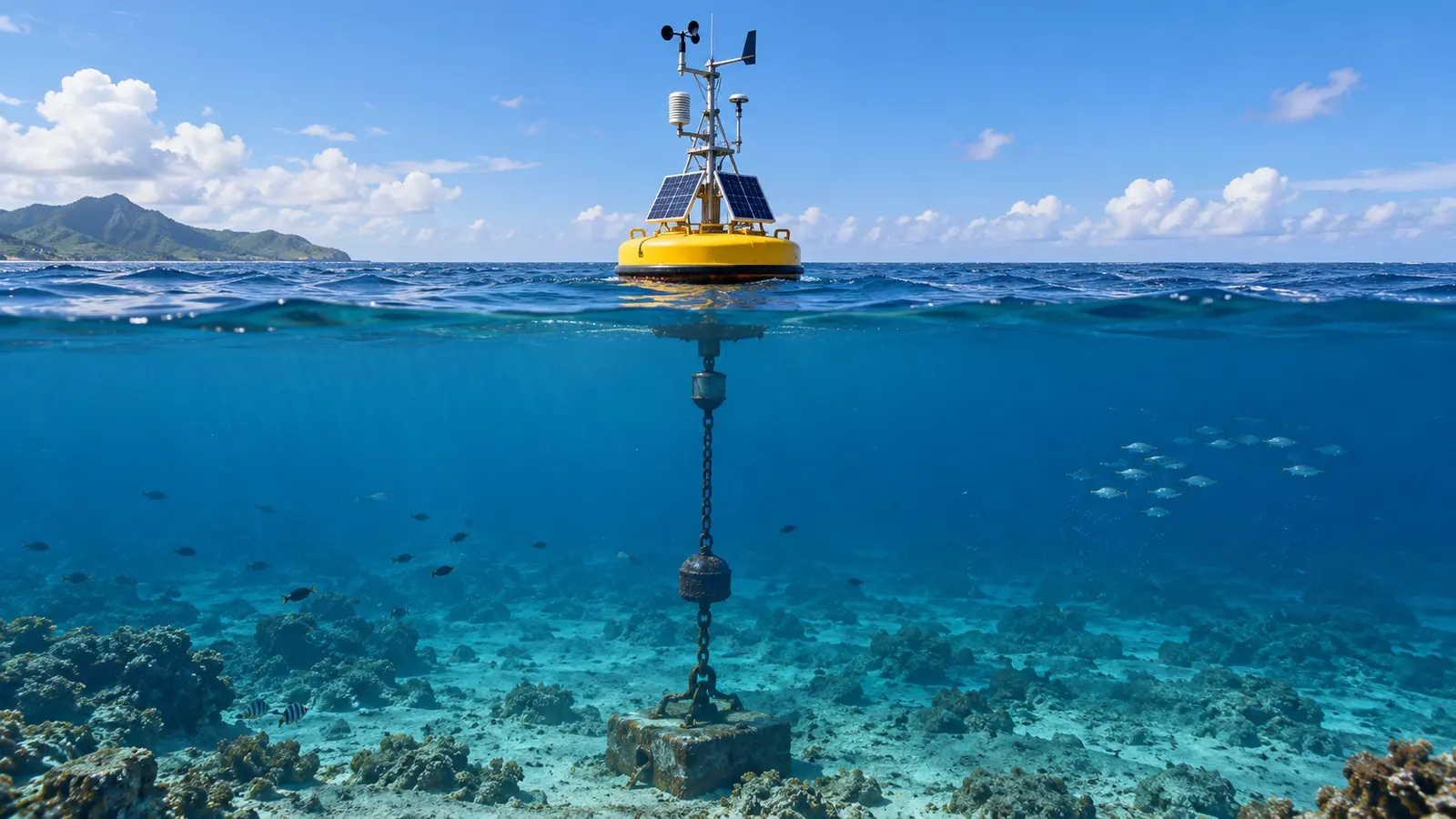
A moored buoy is connected to an anchor or heavy sinker on the seabed. The connection may include chain, wire rope, synthetic line, swivels and elastic sections. Engineers choose the arrangement for the water depth, expected waves, current, seabed and weight of the buoy.
The line is not always pulled perfectly vertical. Many systems use extra length so the mooring can absorb movement instead of snapping under every large wave. For that reason, a buoy normally moves around its charted position inside an area called a watch circle. A vessel should not assume the anchor lies directly below the floating body.
Two broad mooring arrangements are common. A taut mooring keeps the line under tension and limits horizontal movement. A slack or catenary mooring uses the weight and curve of chain or line to absorb load, giving the buoy a larger watch circle. Deep-ocean systems may combine buoyant sections, elastic line and specialised releases. The safest design depends on depth and environmental forces; it is not simply a matter of using the heaviest possible anchor.
The mooring itself may carry instruments at several depths. Researchers can then measure temperature, salinity, currents or oxygen through part of the water column, not only at the surface. Maintaining this equipment is demanding: crews must recover the system, clean it, replace worn parts, calibrate sensors and deploy it again.
All about buoys used for navigation
Navigation buoys communicate through combinations of colour, shape, numbers, topmarks and light rhythms. The internationally harmonised framework is described in the IALA Maritime Buoyage System. A mariner reads all available clues together and confirms them against an up-to-date nautical chart. One colour by itself is not enough.
Lateral marks
Lateral marks define the sides of a channel. The world uses two IALA buoyage regions. In Region A, red marks identify the port side of a channel when entering from seaward, while green marks identify starboard. In Region B, the lateral colours are reversed: red is kept to starboard and green to port when entering from seaward.
This difference explains why a rule memorised in one country may be unsafe in another. Region B includes the Americas, Japan, Korea and the Philippines, while much of Europe, Africa, Asia, Australia and the Middle East uses Region A. Local charts and official sailing information remain the authority.
| Entering from seaward | IALA Region A | IALA Region B |
|---|---|---|
| Port side of channel | Red; cylindrical or can shape when shape is meaningful | Green; cylindrical or can shape when shape is meaningful |
| Starboard side of channel | Green; conical shape when shape is meaningful | Red; conical or nun shape when shape is meaningful |
The “entering from seaward” rule is a useful introduction, but waterways can have an officially defined conventional direction of buoyage that is not obvious from where a boat is travelling. Channel junctions may use modified lateral marks with horizontal colour bands to show the preferred channel. Charts, notices and local authority guidance settle any uncertainty.
Cardinal marks
Cardinal marks use black-and-yellow bands, two black cone-shaped topmarks and distinctive white-light rhythms. They show where safe water lies in relation to the mark: north, east, south or west. Their patterns are based on the compass and work the same way in both buoyage regions.
| Cardinal mark | Colour pattern | Topmark | Basic white-light clue | Meaning |
|---|---|---|---|---|
| North | Black above yellow | Both cones point up | Continuous quick or very quick flashes | Pass to the north; safe water is north of the mark |
| East | Black-yellow-black | Two cones with their bases together | Group of 3 quick or very quick flashes | Safe water is east of the mark |
| South | Yellow above black | Both cones point down | Group of 6 quick or very quick flashes followed by a long flash | Safe water is south of the mark |
| West | Yellow-black-yellow | Two cones with their points together | Group of 9 quick or very quick flashes | Safe water is west of the mark |
The numbers 3, 6 and 9 correspond to positions on a clock face; north uses uninterrupted quick flashes. The long flash after the south group helps prevent six flashes from being confused with three or nine.
Other common marks
- Isolated danger mark: placed on or near a small hazard with navigable water around it. It is black with one or more red horizontal bands, carries two black spheres and normally shows a white group-flashing light of two flashes.
- Safe water mark: indicates navigable water around the mark and may identify mid-channel or landfall. It has red-and-white vertical stripes, may carry a single red sphere and uses a white light with an authorised safe-water rhythm.
- Special mark: yellow, with an optional yellow X topmark, used to show an area or feature explained on the chart—such as a cable, recreation zone, spoil ground or ocean-data station. Its yellow light rhythm must not be confused with other marks.
- Emergency wreck marking buoy: may temporarily mark a newly discovered wreck or danger. Its blue-and-yellow vertical stripes, upright yellow cross topmark and alternating blue-and-yellow light distinguish it while authorities assess longer-term marking.
Private, local and regulatory buoys can use additional systems. A yellow buoy does not automatically mean one universal thing, and a small unlit marker can be difficult to see in poor weather. Anyone operating a boat should learn the system used locally rather than trying to identify marks from a general photograph online.
Buoy shapes and numbers
A cylindrical buoy is often called a can; a conical buoy may be called a nun. Other bodies include spherical, pillar and spar shapes. The hull shape is most useful when a system assigns it a specific meaning. Large lighted or sound buoys may use pillar or spar bodies whose colour, light and topmark carry the message instead.
Letters and numbers help identify a particular aid and may follow a channel sequence. They are not universal instructions by themselves. For example, the odd/even convention familiar to a Region B boater should not be projected onto every waterway worldwide. Match the mark to the official chart.
Why do buoys flash in different patterns?
At night, the colour and rhythm of a buoy’s light help identify it. One light may flash once every few seconds; another may show groups of flashes, quick flashes or a long flash. The interval, colour and grouping form a recognisable characteristic listed on nautical charts and in official light lists.
Modern lights often use LEDs powered by rechargeable batteries and solar panels. Some buoys also carry sound signals, radar reflectors or radar beacons. Newer aids may broadcast identification or safety information electronically, but electronic navigation does not make the physical mark unimportant. A visible buoy provides an independent real-world reference when equipment fails or a vessel’s position is uncertain.
Light abbreviations seen on charts
Charts and light lists use compact abbreviations. “Fl” means flashing, “Q” quick flashing, “VQ” very quick flashing, “LFl” long flashing, “Iso” isophase and “Oc” occulting. A number in brackets describes a group, while the following time gives the full period. The exact symbols and abbreviations should be learned from the chart authority that issued the chart; guessing a rhythm from memory is unsafe.
Physical, synthetic and virtual aids
AIS aids to navigation can add an electronic symbol and identity to a compatible display. A message may come from equipment on a physical aid, be transmitted synthetically from another location for an existing physical mark, or represent a virtual aid where no buoy is physically present. Virtual aids can mark a temporary or difficult location quickly, but they are visible only to properly equipped users. The symbol on a screen and the object in the water are related sources of information, not interchangeable guarantees.
All about buoys used for weather and ocean data
A data buoy is built to observe the environment rather than guide a vessel through a channel. Depending on its instruments, it can measure wind speed and direction, air pressure, air temperature, sea-surface temperature, wave height, wave period and wave direction. Some platforms also observe currents, salinity, dissolved oxygen, chlorophyll, carbon dioxide or other water-quality indicators. NOAA’s National Data Buoy Center measurement guide is a useful example of why the parameter, unit, sensor position and observation time all matter.
Measurements are recorded by a data logger and transmitted to shore, commonly through satellite or radio links. Weather services use buoy observations to check forecasts and monitor storms. Ships and coastal communities use them to understand current sea conditions. Scientists combine long records from many stations to study changing oceans and improve models.
A buoy reading still needs context. Wave height is calculated from a sampling period rather than guessed from one visible crest. Wind is measured at a stated sensor height. A sea-temperature sensor may sit below the waterline, while air temperature is measured above it. Station pages therefore list sensor heights, depths, units and quality-control information.
How to read a buoy station report
Start with the station identifier, coordinates and observation time. Check whether the time is local or UTC and whether the latest report is recent enough for your purpose. Next, look at units: wind may be shown in knots or metres per second, wave height in feet or metres, and pressure in hectopascals.
Wave height usually refers to significant wave height, a statistical value representing the average of the highest third of measured waves. Individual waves can be higher. Wave period describes the time between crests and changes how the sea feels; a long-period swell can carry substantial energy even when its height seems moderate. Finally, note missing values and quality flags. A blank field does not mean calm conditions—it may simply mean that sensor did not report.
Drifting buoys and profiling floats
Not every scientific buoy is anchored. A drifting buoy travels with surface currents, often using an underwater drogue or sea anchor so its movement better represents the water rather than only the wind. Its position and measurements are sent by satellite. Networks of drifters reveal how currents transport heat, debris and water across the ocean.
Profiling floats go farther. An Argo float changes its buoyancy to descend into the ocean, drift at depth and later rise while measuring temperature and salinity. At the surface it transmits the profile and receives instructions before beginning another cycle. Although people often casually call every floating instrument a buoy, profiling floats operate differently from a conventional surface mooring.
Argo floats use pumps to move oil between an internal reservoir and an external bladder. Changing the float’s volume changes its buoyancy. Most of the operating cycle is spent below the surface, which reduces exposure to storms and allows measurements through the water column. Some specialised floats also measure oxygen, nitrate, pH, chlorophyll and suspended particles.
How tsunami buoys actually work

A so-called tsunami buoy is more than the object seen at the surface. NOAA’s DART systems pair a surface communications buoy with a bottom pressure recorder anchored on the seafloor. The recorder detects pressure changes caused by changes in the water column. It sends data acoustically to the surface buoy, which relays the information by satellite to stations on shore.
This matters because a tsunami in deep water may be difficult to recognise by sight. The full system helps warning centres confirm whether a tsunami was generated and refine forecasts. It does not work as a lone alarm siren for the nearest beach, and it does not replace seismic networks, tide gauges, modelling or official emergency communication.
For the same reason, a damaged or missing surface buoy is not a minor inconvenience. It can interrupt a valuable observation link. Tsunami systems are placed strategically and maintained as part of a wider warning network.
All about buoys used for other jobs
Mooring buoys provide an approved point to which a vessel can secure. They are designed for a specified load and are different from navigation marks. A skipper should use only a mooring known to be suitable for the vessel.
Swimming and recreational buoys separate swimmers from boats, outline a course or mark a controlled area. Fishing buoys can identify nets, pots or longlines. Regatta buoys mark a racing course. Construction buoys may define a work zone or submerged pipeline. Marine-protected-area buoys can show where anchoring, fishing or entry is restricted.
There are also specialised platforms for tracking whales, listening for underwater sound, detecting harmful algal blooms, monitoring water quality and supporting offshore energy projects. The same basic idea—a visible floating platform—can carry remarkably different equipment.
Specialised buoy examples
- Wave-measurement buoy: uses motion sensors or other instruments to calculate wave height, direction and period.
- Ice buoy: deployed on or near sea ice to report position and environmental measurements as the ice drifts.
- Acoustic or listening buoy: carries hydrophones to record underwater sound for research, monitoring or defence. A sonobuoy is a specialised expendable acoustic system, not a navigation mark.
- ODAS buoy: an Ocean Data Acquisition System collecting meteorological or oceanographic information; when treated as a special mark, its charted purpose still needs to be checked.
- Fish-aggregating device marker: identifies equipment intended to attract fish; legal markings and permitted use differ by jurisdiction.
- Subsurface buoy: provides buoyancy below the surface for an instrument or mooring and may not be visible to passing vessels.
- Marker or recovery buoy: helps crews relocate an anchor, instrument, diver, cable or other object.
- Racing buoy: defines part of a sailing, rowing, swimming or powerboat course and may be temporary.
These categories can overlap. A yellow special mark may protect a scientific mooring whose instruments extend far below it, while a weather buoy may also carry a navigation light so vessels can avoid it.
How a buoy is designed and deployed
The process begins with a defined purpose and site survey. Designers estimate wind, wave, current, tide and ice loads; examine water depth and seabed; choose visibility and communications requirements; and decide how crews will maintain the system. The buoy, payload, mooring and anchor must be engineered as one system.
Before deployment, instruments are calibrated, batteries and lights are checked, identifiers are programmed and the complete mooring is laid out in deployment order. A vessel lowers the anchor and line according to a planned procedure, verifies the final position and tests communications. For a navigation aid, the responsible authority records and publishes its characteristics so charts and notices can be updated.
Recovery may be as difficult as deployment. Crews sometimes use an acoustic release to disconnect an instrument from its seabed weight. Large navigation buoys require lifting equipment, careful handling of heavy chain and safe work in moving water.
Maintenance: why buoys need regular attention
Saltwater equipment is never “fit and forget.” Technicians inspect hulls, welds, shackles, chains, swivels, lights, batteries, antennas and solar panels. Sensors are cleaned and recalibrated. Worn mooring parts are replaced before they fail. Paint and reflective material are renewed so the mark keeps its intended daytime appearance.
Biofouling—the growth of algae, barnacles and other organisms—can add weight, block sensors and change water flow around an instrument. Corrosion attacks metal, sunlight weakens some polymers and repeated loading causes fatigue. Maintenance intervals therefore depend on the site and equipment rather than one universal schedule.
Some buoys are removed seasonally to avoid ice or severe weather. Others remain year-round because continuous observation or navigation safety is more important. When a required aid is temporarily unavailable, authorities may issue a notice, install a replacement or use another marking method.
Can a buoy move, fail or disappear?
Yes. Mooring lines wear, anchors drag and storms can push a buoy off station. Ships may strike it, vandals may damage it and fishing gear can become entangled. Batteries, lights, sensors and transmitters can fail. Heavy marine growth changes weight and sensor performance. Ice can remove or damage seasonal marks.
Navigation authorities publish notices when an aid is missing, off station or unreliable. Electronic charts also require updates. A buoy’s absence does not mean the hazard has disappeared, and a buoy found in an unexpected position should not be used as the only evidence of a vessel’s location.
A buoy can also appear correct while one function has failed. Its body may remain on station even though the lantern, sound signal, sensor or transmitter is not operating. Conversely, a working AIS symbol does not prove that a physical buoy is exactly where expected. Safe navigation cross-checks the chart, position, depth, surroundings and official notices.
Why you should not climb on, tie to or move a buoy
A navigation or data buoy is public-safety infrastructure, not a free mooring. Tying a boat to it can damage the light, sensors, solar panels or mooring and may pull the mark away from the position it is meant to identify. A heavy buoy also rises and falls differently from a small boat, creating a crushing or entanglement hazard.
Keep clear unless the object is specifically designated as a mooring and you have permission to use it. Do not climb on a buoy, remove equipment or cut a line. If a mark appears damaged, adrift or off station, record its location from a safe distance and report it to the relevant coastguard, port or navigation authority.
Fishing line, nets and anchor gear can foul a buoy’s mooring or submerged instruments. Give scientific and special-purpose buoys generous clearance, especially when the underwater footprint is unknown. Never attempt to recover an unfamiliar drifting device unless the responsible authority instructs you to do so; note its position and identification safely instead.
How buoy observations reach a weather app
The journey from sea to screen involves more than a sensor. An instrument takes a measurement; electronics timestamp and store it; a transmitter sends it through radio, mobile or satellite communications; a receiving system applies automated quality checks; and the data enter forecasting and public-information services.
Not every reading appears instantly, and not every app shows raw buoy data. Some displays combine observations with model estimates. A station may temporarily stop reporting even though it remains physically present. For safety-critical decisions, users should consult the original station page, its observation time and official marine forecasts.
Ocean observations also help explain larger climate patterns. For example, scientists watch sea temperatures, winds and pressure across the tropical Pacific when assessing El Niño forecasts. No single buoy declares an El Niño; agencies evaluate a network of observations and models.
Frequently asked questions: all about buoys
Are all buoys anchored?
No. Navigation and many weather buoys are moored, but drifting buoys are intentionally carried by currents. Profiling floats repeatedly descend and surface.
Does a red buoy always mean the same thing?
No. The lateral meaning of red and green reverses between IALA Regions A and B. The buoy’s shape, number, light, charted purpose and direction of buoyage must also be considered.
How are ocean buoys powered?
Many use solar panels and rechargeable batteries. Smaller devices may rely on long-life primary batteries, while specialised systems choose power arrangements suited to their instruments and deployment length.
Can a buoy predict a tsunami?
A DART system detects pressure changes associated with a passing tsunami and reports data used in forecasts. It does not predict the earthquake in advance, and it works as one part of a wider warning system.
Why are some buoys much larger than others?
Size reflects purpose, visibility, stability, instrument load, power needs and expected sea conditions. A harbour marker and an offshore weather station solve very different engineering problems.
Why do some buoys have bells, whistles or horns?
Sound signals help mariners detect certain aids when visibility is poor. Movement may operate a bell or gong, while powered equipment can produce a programmed signal. The sound characteristic and range vary, so official chart and light-list information remain necessary.
How heavy is a buoy?
There is no standard weight. A small marker can be handled by one person; a large steel ocean or navigation buoy, together with chain and sinker, can weigh many tonnes. Size alone does not reveal the weight of the underwater system.
How deep can a buoy be anchored?
Moorings range from shallow swimming areas to deep-ocean sites thousands of metres deep. Deep water requires specialised line, buoyancy, deployment methods and load calculations.
What should I do if I find a buoy on a beach?
Do not open, dismantle or take it. Photograph identifying marks from a safe position, note the location and contact the local coastguard, port, police or organisation named on the device. Batteries, sharp hardware and pressurised or specialised equipment may be present.
Are buoy observations always accurate?
No instrument is perfect. Agencies apply automated and human quality control, but sensors can drift, foul or fail. Check flags, observation time and nearby stations, especially when a value looks unusual.
Can I navigate using only buoys?
No. Buoys can move, disappear or malfunction. Use them with official charts, depth information, position fixing, notices to mariners, weather information and a proper lookout.
A small object with a large responsibility
Buoys make invisible information visible. They turn the edge of a channel into a line a navigator can follow, convert moving waves into measurements, carry observations from remote oceans and help protect areas that cannot be fenced.
The most important lesson from learning all about buoys is that appearance is only the beginning. Colour, shape, light, position and published purpose work together. Whether a buoy is guiding a ship or sending data from the deep ocean, it deserves space, protection and careful interpretation.
Transparency
Sources & references
Editorial review pending
Editorial information
SOAKJAM articles are designed for clarity, useful context and transparent sourcing. Important facts should be checked against the linked primary sources.
Found an error, outdated detail or a useful source we should consider?